Wednesday, February 23, 2011
GLORY Launch Re-set for Feb 24th (15:30 on NASA-TV)
The milestone GLORY mission (seen here at sunset today on the pad), to collect real measurements of Earth's radiation balance was scrubbed yesterday, but is re-set to try again tomorrow from Vandenburg, just hours before the final launch of Space Shuttle Discovery. Should be a big day for NASA, and space fans everywhere - HLG
If you like Friday (the 25th of Feb) Storm, you will ...
Tuesday, February 22, 2011
Monday, February 21, 2011
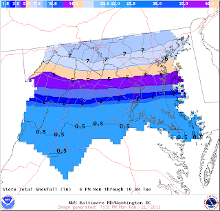
DC Snow Depends on Which Side of Metro
160 mph winds?
http://www.thesun.co.uk/sol/homepage/news/3424182/Girl-in-bouncy-castle-horror.html
I'm sure there was more damaged than just the bouncy castle!
BB
I'm sure there was more damaged than just the bouncy castle!
BB
Saturday, February 19, 2011
Thursday, February 17, 2011
Tuesday, February 15, 2011
Thursday, February 10, 2011
Tuesday, February 8, 2011
TC "Yasi" Plus One Week
Super Snow 45 in Dallas!
NASA 3D Sun iPhone App
3D Sun for the iPhone
Imagine holding the entire sun in the palm of your hand. Now you can. A new iPhone app developed by NASA-supported programmers delivers a live global view of the sun directly to your cell phone. Users can fly around the star, zoom in on active regions, and monitor solar activity.
"This is more than cool," says Dick Fisher, director of NASA's Heliophysics Division in Washington DC. "It's transformative. For the first time ever, we can monitor the sun as a living, breathing 3-dimensional sphere."
Screen capture of 3D Sun on the iPhone. The application allows users to spin the sphere by flicking it and zoom in by pinching the screen. Credit: NASA
› Larger image The name of the app is "3D Sun" and it may be downloaded free of charge at Apple's app store. Just enter "3D Sun" in the Store's search box or visit http://3dsun.org for a direct link.
Realtime images used to construct the 3-dimensional sphere are beamed to Earth by the Solar-Terrestrial Relations Observatory (STEREO), a pair of spacecraft with a combined view of 87% of the solar surface. STEREO-A is stationed over the western side of the sun, while STEREO-B is stationed over the east. Together, they rarely miss a thing.
Telescopes onboard the two spacecraft monitor the sun in the extreme ultraviolet (EUV) portion of the electromagnetic spectrum. "That's why the 3D sun looks false-color green," explains Lika Guhathakurta, STEREO program scientist at NASA Headquarters. "These are not white-light images."
That's okay because EUV is where the action is. Solar flares and new sunspots shine brightly at these wavelengths. EUV images also reveal "coronal holes," vast dark openings in the sun's atmosphere that spew streams of solar wind into the solar system. Solar wind streams that hit Earth can spark intense displays of Northern Lights.
"With this app, you can spin the sun, zoom in on sunspots, inspect coronal holes--and when a solar flare erupts, your phone plays a little jingle to alert you!" says Guhathakurta.
Indeed, many users say that's their favorite part -- the alerts. The app comes alive on its own when the sun grows active or when interesting events are afoot. For example, a recent alert notified users that a comet just discovered by STEREO-A was approaching the sun. When the comet was destroyed by solar heating, the app played a movie of Comet STEREO's last hours.
Representative screenshots from the app -- from left to right, a prominence caught in mid-eruption by STEREO-B, a sample of the daily news screen, and a sungrazing comet movie recorded by STEREO-A. Credit: NASA
› Larger image
Another remarkable aspect of the app is that it shows the far side of the sun -- the side invisible from Earth. "This means sunspots cannot take us by surprise," Guhathakurta points out.
Recently, STEREO-B was monitoring a far side sunspot (AR1041) when the sunspot's magnetic field erupted. For the first time in almost two years, an active region on the sun produced a strong "M-class" solar flare. The unexpected interruption of the sun's deep solar minimum was invisible from Earth, but anyone with the 3D Sun had a ringside seat for the blast.
3D Sun was created by a team of programmers led by Dr. Tony Phillips, editor of Science@NASA. He says that version 1 of the app is just the beginning. Soon-to-be released 3D Sun 2.0 will offer higher-resolution images and multiple extreme ultraviolet wavelengths (preview). These additions will reveal even more solar activity than before
Monday, February 7, 2011
Wednesday, February 2, 2011
Winter Storm Waning HOUSTON!
You just don't get to say that every day (or even every 10 winters), so hang on Houston, this should get interesting! - HLG
1144 AM CST WED FEB 2 2011
...WINTER STORM WATCH IN EFFECT FROM THURSDAY AFTERNOON THROUGH
FRIDAY MORNING...
THE NATIONAL WEATHER SERVICE IN HOUSTON/GALVESTON HAS ISSUED A
WINTER STORM WATCH...WHICH IS IN EFFECT FROM THURSDAY AFTERNOON
THROUGH FRIDAY MORNING.
AN UPPER LEVEL STORM SYSTEM APPROACHING FROM THE WEST WILL
COMBINE WITH INCREASING MOISTURE AND COLD TEMPERATURES IN THE
ATMOSPHERE TO GENERATE A MIX OF SNOW...SLEET...AND FREEZING RAIN
ACROSS SOUTHEAST TEXAS THURSDAY AFTERNOON THROUGH FRIDAY MORNING.
THE PRECIPITATION IS EXPECTED TO BEGIN THURSDAY AFTERNOON
ESPECIALLY ACROSS THE SOUTHERN HALF OF THE AREA...AND SPREAD AREA
WIDE BY EARLY EVENING. THE WINTRY MIX WILL CONTINUE THURSDAY NIGHT
THEN TAPER OFF AROUND MID MORNING FRIDAY.
A MIXTURE OF SNOW...SLEET...AND FREEZING RAIN IS EXPECTED EAST OF
A LINE FROM MATAGORDA TO DOWNTOWN HOUSTON TO RYE IN LIBERTY
COUNTY. OVER THE COASTAL SECTIONS OF BRAZORIA COUNTY...AND MOST OF
GALVESTON...CHAMBERS...AND LIBERTY COUNTIES THIS COULD END UP A
PRIMARILY ICE EVENT WITH SIGNIFICANT GLAZING ON ROADWAYS. TO THE
NORTH AND WEST OF THIS LINE...A MIX OF SNOW AND SLEET ARE
EXPECTED...WITH ALL SNOW ACROSS THE NORTHWEST HALF OF SOUTHEAST
TEXAS.
SNOW AND SLEET ACCUMULATIONS OF 1 TO 3 INCHES ARE EXPECTED...WITH
LOCALLY HIGHER AMOUNTS POSSIBLE. IN THE FREEZING RAIN THREAT
AREA...ICE ACCUMULATIONS OF UP TO ONE-TENTH OF AN INCH ARE
EXPECTED. THIS INCLUDES THE SOUTHERN AND EASTERN PORTIONS OF THE
METRO HOUSTON AREA AND THE GALVESTON AREA AS WELL.
SURFACE TEMPERATURES ARE EXPECTED TO BE IN THE MID 20S TO LOWER
30S THROUGH THE DURATION OF THE EVENT. THIS MEANS THAT
ROADWAYS...ESPECIALLY ELEVATED SURFACES LIKE BRIDGES AND
OVERPASSES...ARE MUCH MORE LIKELY TO ICE OVER THAN DURING THE
EVENTS SOUTHEAST TEXAS EXPERIENCED LAST WINTER. ROADWAYS WILL
LIKELY BECOME ICY AND HAZARDOUS THURSDAY NIGHT AND FRIDAY MORNING.
WINTER WEATHER
Your FWSAAB crew have been working day and night (on our Pro site...) to keep our faithful readers informed and up-to-date on the latest Snowzilla (has that been used yet?).
However, to alert the general public about the possibility of hell freezing over - we give our free site readers an image of the GFS run from a few hours ago.
Image courtesy of Penn State's (the other University of Oklahoma) e-wall.
The model (and most other models) show the -10 C isotherm over FWSAAB's HQ. Will the Bay of St. Louis freeze again (as happened in 1989). Only time will tell.
Time to move farther south.
Stay tuned to FWSAAB (our Pro Site) for the latest snowcropolis information. Free site readers are screwed.
BB
Subscribe to:
Posts (Atom)