Friday, November 18, 2011

Mystery of West Coast Rocket Solved?

I find it hard to believe that the military's newly announced hypersonic weapon system is unrelated to the "non-rocket/nothing-to-see-hear" rocket launch we all witnessed off the west coast last year.


U.S. Army Tests Secret Hypersonic Weapon

Published November 17, 2011
Technews Network
The U.S. Army's hypersonic weapon prototype streaked across the Pacific Ocean at several times the speed of sound Thurs., Nov. 17, in a flawless maiden test flight. The success could pave the way for a new military capability to strike targets anywhere on Earth in as little as an hour.
Such a hypersonic weapon concept flies at a relatively flat trajectory within the atmosphere, rather than soaring up toward space like a ballistic missile and eventually coming back down. Hypersonic speed is defined as being at least five times the speed of sound (3,805 mph, or 6,124 kph, at sea level). An unmanned aircraft that can travel at a breakneck pace 20 times the speed of sound will take off Wednesday from an Air Force base in California for a test flight.
The Army's Advanced Hypersonic Weapon launched aboard a three-stage booster system from the Pacific Missile Range Facility on the island of Kauai in Hawaii at 6:30 AM ET, deployed for its hypersonic glide, and eventually splashed down in the Reagan Test Site located near the Kwajalein Atoll.
Pentagon officials kept a careful watch on the flight test from space, air, sea and ground. That allowed them to collect data about aerodynamics, navigation, guidance, and control performance, as well as thermal protection technologies meant to shrug off intense heat during hypersonic flight.
Such success may provide some consolation to DARPA, given that its Falcon Hypersonic Technology Vehicle 2 (HTV-2) experienced problems in its two test flights that led to early crashes. HTV-2 reached a speed of Mach 20 during its latest test in August.
The Air Force has also tested its own X-51A Waverider vehicle, most recently on June 13, as an experimental platform for an air-breathing scramjet engine. During the latest test, the X-51A Waverider reached hypersonic speeds of at least Mach 5 before it failed to switch over to its main fuel source.
Having several hypersonic projects resembles the early days of U.S. rocket and missile development, when the Army and Air Force competed to get their rockets off the ground. But any success in the hypersonic realm seems likely to benefit the U.S. military's unified goal for a "Conventional Prompt Global Strike" weapon designed to speedily attack targets around the world

Yet another GIS application in the weather-world


Storm Chaser

Amica Mutual Insurance Maps Real-Time Data, Providing Better Service to Policyholders

By Karen Richardson
Esri
Because many Amica Mutual Insurance policyholders owned homes or other property in the path of Hurricane Irene, the company wanted to ensure that it had adequate resources to provide services when these people needed them most. Amica, a provider of personal insurance for autos, homes, and boats, is headquartered in Lincoln, Rhode Island. Known in the industry for its high standard of customer service, the company has been awarded several J.D. Power and Associates customer satisfaction awards.
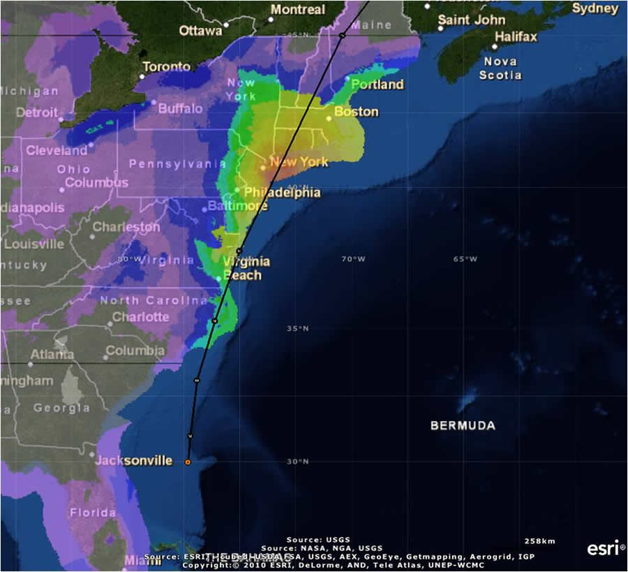
ArcGIS used to track Hurricane Irene.
Amica used ArcGIS to track Hurricane Irene and view forecasted wind speeds from the National Oceanic and Atmospheric Administration's NowCoast Web Map Services. This map displays the storm one day prior to making landfall in North Carolina.
Amica monitored Irene last summer as the hurricane moved up the East Coast of the United States, using real-time weather warnings from the National Oceanic and Atmospheric Administration (NOAA). This information, which included live radar loops focused on the strongest parts of the storm, was brought into Esri's ArcGIS Online as map services, a standard way to view location-based information on the web. By viewing live data streams and comparing them with internal policy data, Amica personnel were able to watch the storm in real time and quickly identify which areas were likely to generate the most claims.
Before their eyes, the path of destruction passed through North Carolina, Virginia, and all the way up the East Coast. "Our exposure along the forecast track was significant, and we immediately knew this would be a big event for us," said Adam Kostecki, a claims examiner in the Property Loss Division at Amica Mutual Insurance.
When tracking Irene, Kostecki combined real-time event tracking and geocoded policy locations displayed in ArcGIS. Taking a NOAA map service that forecasted wind speed and creating it as an ArcGIS web mapping service (WMS), Kostecki was able to input where Hurricane Irene was moving in real time on a map, along with Amica's plotted policies. He and other personnel drew lassos around policies in the areas they were interested in. The lasso Select tool allowed Amica staff to select multiple policies in contiguous areas without being restricted by administrative or geographic boundaries. Combining both datasets—wind speed high enough to cause damage plus policies in the area—Amica found out the number of policies that might be at risk.
By viewing the policy locations along with the area of impact, Kostecki could find out exactly which policies were in the path of the event and generate reports for claims adjusters quickly. "Simply by viewing and exploring the data in ArcGIS, I simplified and improved the accurate identification of customers in Hurricane Irene's impact area," said Kostecki.
For insurers, knowing precisely where damage has occurred is paramount in developing a timely and appropriate response. The quicker an insurer can respond to claims, the faster people can rebuild and continue on with their lives. Being able to determine exposures in different areas, as well as knowing the likely severity of the damage, allowed the Amica claims department to proactively plan for potential claims volume. "Once Irene passed, we plotted claims as they were reported," said Kostecki. "Waiting days for first-responder reports, damage models, or even post-event aerial imagery just isn't an option anymore when responding to catastrophes."
Knowing how many policyholders might be affected helped Amica better determine how many adjusters were needed and where they should be sent after Hurricane Irene passed. From the information gathered in ArcGIS, the staff was able to generate a quick summary and export the information into a report. This information provided a better picture of how many claims Amica might need to respond to in a certain geographic area.
"We had a much better idea of what our claim potential was going to be after this event," said Kostecki. "And even better, we had this information ready to go hours after the storm."
Amica implemented the use of GIS in claims about five years ago, in order to better estimate the company's exposure after a catastrophic event such as a hurricane, earthquake, wildfire, or tornado. Knowing this information helps Amica ensure that it is appropriately staffed to handle the volume of claims that might be reported. Since implementing GIS technology, Amica has realized that pushing this technology to the front lines could have a profound impact on the way it services its policyholders. Kostecki explained, "It's a technology that our staff embraces—because it makes their jobs easier, and it allows them to be more efficient."
For more information on how ArcGIS is used in the insurance industry, visit esri.com/insurance.

Wednesday, November 16, 2011

Song Heard in Dubai

This was actually heard in Dubai during a fog event...

Dubai Skyscrapers in the Fog

Amazing picture from NatGeo.  The humidity is still very high in the southern Persian Gulf this time of year, but as the mornings are chillier, thick advection sea-fogs roll in amongst some of the tallest buildings on Earth., reminding me of the uber-geeky Cloud City of Star Wars Epsidode 6. -HLG

Tuesday, November 15, 2011

AN OPEN LETTER - FROM FWSAAB CORP.

Dear Readers,

I, Sterling Gonads, as the new President of FSWAAB Corp (a subsidiary of the Environment Channel and part of the Universal Global Broadcasting System - UGBS), openly apologize for the crude, unsolicited and unapproved comments made by HLG recently.  We at FSWAAB believe in a caring, open and green blog - one that is carefully controlled by our managers at UGBS (UGBS +5% FTSE).  We will not allow crass and ungreen-like statements made by our on-blog geographers who like to pretend that they have a meteorology background.

At FWSAAB, we will ensure the reading blog public that irreverent and humorous commentaries from HLG, BB - and the others who haven't been heard from in years - will continue.  However, the management will also take a hard-line against hurtful statements that go against our public options on the open market.

FWSAAB will be making some exciting changes in the coming weeks to bring it more inline with our other media products like the Environment Channel, UGBS Network News and the Friend Channel.   We will also start including famous meteorologists to make on-blog appearances, some of which appeared on another weather-type channel.  Soon we will also roll out our new Spanish Blog "El Clima de Cuatro Hombres y Una Guapa Chica (ECCHUGC)"

At FWSAAB, we believe in making the environment exciting.  Stay tuned.

Sincerely,
Sterling Gonads, esq.

Sunday, November 13, 2011

North Sea Island "Ship-wakes"

Some of the most complicated island-ship-wakes I have ever observed.  Must have something to do with the "Epic" Storm in Alaska. - HLG

Saturday, November 12, 2011

Loading Up in Alaska

Alaska will be plunged into quite a cold morass after the "epic" storm of 2011.  All this cold air is preparing to spill down into the central plains and possibly into the deep south.  Should be a fun trip for Thanksgiving Day drivers across the U.S..

On a lighter note - the owners of FSWAAB would like to point out that their blog employees have not mentioned the Penn State scandal.  Such restraint should be congratulated.

BB